

The Hyde County Commissioners on Tuesday afternoon ordered mandatory evacuation of visitors and residents of the island starting today for visitors and residents tomorrow in advance of the expected arrival of Hurricane Matthew. Click here for an earlier story.
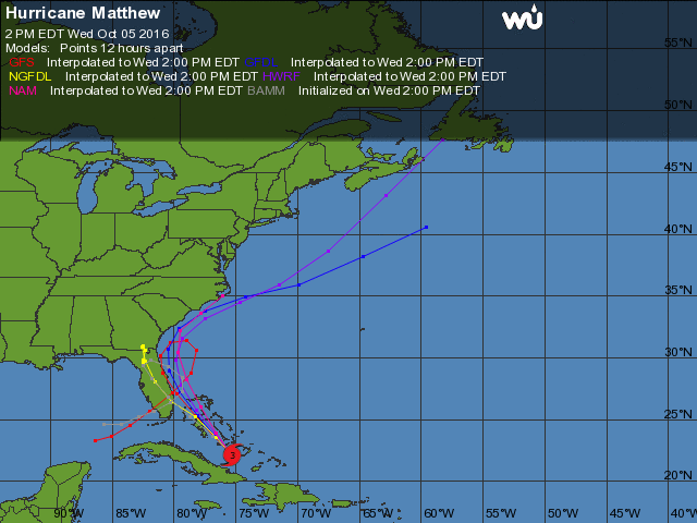
Overnight, the expected track changed lessening the likelihood of a major hurricane strike on Ocracoke. Any changes in the storm direction or a change in the evacuation status will be reported.
From the National Weather Service
Newport/Morehead City, N.C.
Oct. 5, 2016, 5 a.m.
A significant model forecast change in the track of Matthew continues to develop. This has increased uncertainty and the confidence in the forecast threat level for the area is lower. The majority of models now keep the center of Matthew off the coast and actually curve it back to the south. Some models still indicate a track closer to or over Eastern N.C.
- The updated National Hurricane Center forecast takes this into account and shifts the track significantly off the coast. The forecast now keeps the center of Matthew off our coast to the south and east, reducing impacts for our area.
The threat of dangerous life threatening conditions has diminished with the new forecast track, but we urge continued caution across Eastern NC. We are hopeful this model trend continues and the most significant impacts are not realized in Eastern NC. However it is too early to completely let our guard down. It is still within the margin of error for the storm to pass very close to or over our coastal areas.
- Continue to monitor the forecast for future. Have a disaster preparedness kit ready, and plans for what you would do if asked to evacuate.
Hurricane Matthew key points:
Based on the new model trends, the now most likely impacts on Eastern NC will be:
- Minor to moderate storm surge and high surf
- Tropical storm force winds that could produce minor damage along the
- Heavy rainfall and flash flooding is still possible
- Extremely dangerous conditions for Rip currents
Closely monitor the forecast for Matthew in the coming days. Be alert to additional forecast track changes that could increase the danger to our area. Be prepared to take action to protect yourself and your property if needed
For Ocracoke news, click here.