

From our news services
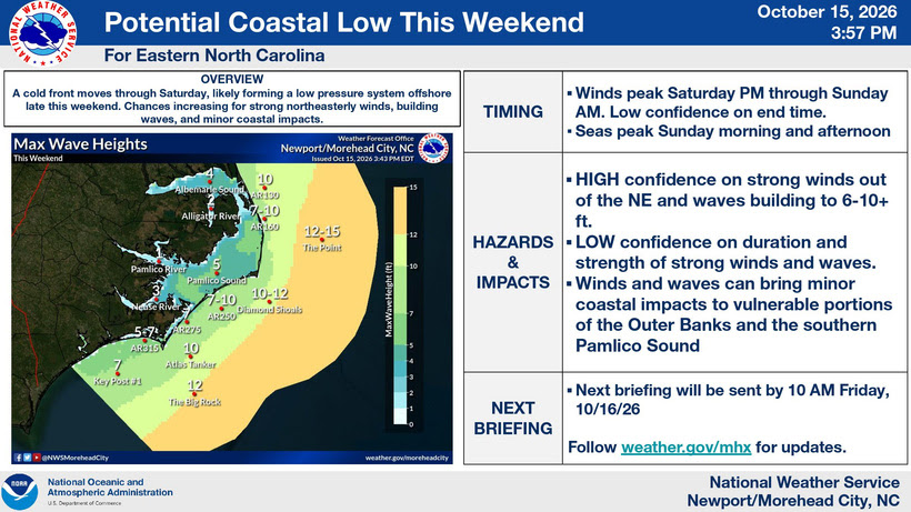
A strong cold front moving through the Outer Banks on Saturday will bring rain, strengthening north to northeast winds and hazardous coastal conditions that could persist into early next week.
Forecasters expect high surf, beach erosion, minor coastal flooding, ocean overwash and an increased threat of rip currents. Strong winds will also create hazardous marine conditions, with gale-force winds possible offshore.
The severity of coastal impacts will depend on how close an offshore low-pressure system develops to the North Carolina coast and how long it lingers in the area. If the low develops and remains nearby, hazardous conditions could continue into next week.
The forecast
Friday: Sunny and breezy, with highs around 80 degrees. Southwest winds of 15 to 20 mph. Mostly clear Friday evening, becoming partly cloudy overnight, with a chance of showers and a slight chance of thunderstorms after midnight. Lows in the lower 60s.
Saturday: Showers and windy conditions as a strong cold front moves through. Highs in the upper 60s, with temperatures falling into the lower 60s during the afternoon. North winds of 20 to 30 mph. Rain is likely, with a 90% chance of precipitation.
Saturday night: Mostly cloudy, with showers mainly during the evening. Very windy, with lows in the mid-50s. North winds of 30 to 35 mph, with gusts up to 45 mph. There’s an 80% chance of rain.
Sunday: Partly sunny, with a 30% chance of showers. Very windy, with highs in the upper 60s.
Residents and visitors should monitor updated forecasts and be alert for coastal flooding, overwash, beach erosion and dangerous surf and rip currents throughout the weekend. Conditions could remain hazardous into early next week.