
By Sam Walker, SamWalkerOBXNews.com
N.C. 12 remained open on Hatteras and Ocracoke islands as of 8 p.m. Wednesday despite blowing sand and minor ocean overwash, with a strengthening coastal storm expected to bring more serious flooding and travel problems Thursday and into Friday.
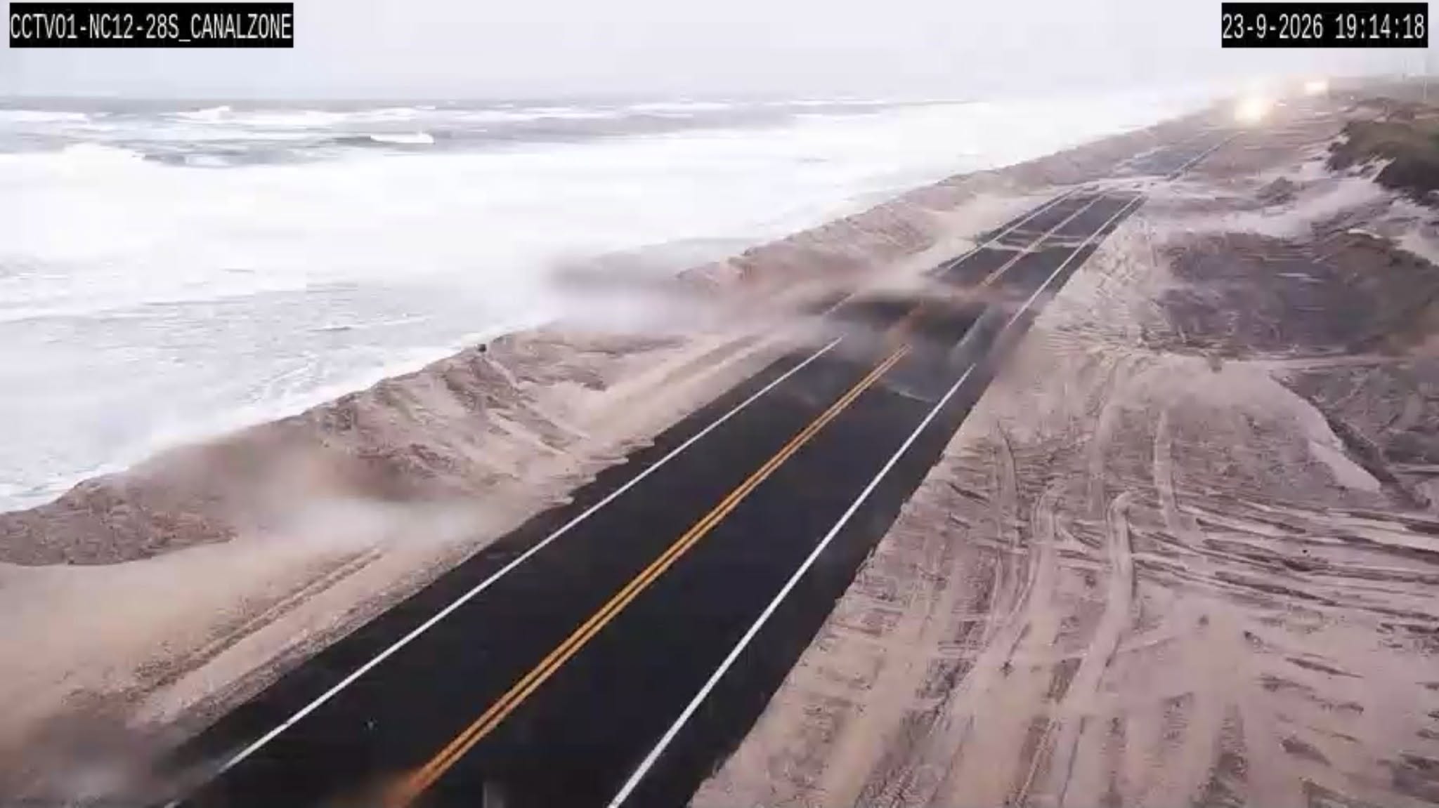
Minor overwash occurred at the usual trouble spots on Pea Island during the evening high tide around 6 p.m. Overwash also was reported in northern Rodanthe, with minor overwash between Frisco and Hatteras village.
Blowing sand was reported along N.C. 12 on both Hatteras and Ocracoke. No road closures had been reported as of 8 p.m.
At least two vehicles parked at oceanfront homes in Rodanthe were damaged by overwash, according to posts on social media.
Hatteras Island faces the greatest impacts in Dare County.
Emergency Management Director Drew Pearson warned that overwash could make travel “hazardous at best,” with a high potential for road closures.
The worst conditions could begin with Thursday morning’s high tide and recur with each high tide, possibly into the weekend.
Vehicle ferry service continued Wednesday night between Hatteras and Ocracoke on an amended schedule.
NCDOT’s live route-status table, checked at 8:43 p.m., listed that route as operating on a limited schedule, with Cedar Island–Ocracoke and Swan Quarter–Ocracoke operating normally.
Service on all three Ocracoke vehicle ferry routes could be suspended Thursday if sustained winds reach forecast levels. Travelers should check the latest route status and posted departures before heading to a terminal.
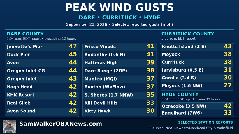
The National Weather Service’s Newport/Morehead City office reported northeast wind gusts of about 35 to 50 mph along the Outer Banks in its evening update.
The highest land-based gust reported by the office as of 8 p.m. was 48 mph at Oregon Inlet. Buoys were reporting seas of 12 to 15 feet in coastal waters north of Cape Hatteras.
The office’s 8:23 p.m. forecast discussion reported no major forecast changes.
Wakefield’s 7:44 p.m. update also left its tidal flooding and marine forecasts unchanged, with persistent northeast winds expected to keep water levels elevated through repeated high tides.
Coastal flood warnings remain in effect for Hatteras and Ocracoke islands and the Currituck beaches.
Forecasts call for 2 to 4 feet of water above normally dry ground in vulnerable areas of Hatteras and Ocracoke, 1 to 3 feet from Duck to Oregon Inlet and 2 to 3 feet along the Currituck beaches.
Wind advisories cover the beaches and mainland portions of Dare and Currituck counties, as well as Ocracoke.
Gusts of 40 to 50 mph could bring down trees, cause scattered power outages and make high-profile vehicles difficult to handle.
Dangerous surf and boating conditions are expected to continue through Saturday, with uncertainty about how quickly conditions will improve.
Forecast: Strong winds into Friday, dangerous seas through Saturday
An offshore low-pressure system and strong high pressure to the north will maintain north to northeast winds along the Outer Banks. The main coastal impacts are expected through Friday night. Seas are forecast to peak Wednesday night into Friday. Thursday evening’s high tide is a particular concern because it could coincide with the strongest wave energy.
The coastal flood warning for Hatteras and Ocracoke remains in effect through 11 p.m. Friday.
The storm coincides with a period of higher astronomical tides. The North Carolina King Tides calendar identifies Sept. 25 through Oct. 14 as a period when higher than normal high tides are possible. A full moon occurs Sept. 26, and the moon reaches perigee, its closest point to Earth, on Oct. 1.


