Home Blog Page 380

Mandatory evacuation for residents suspended

0
The water in Silver Lake Harbor on Wednesday. Photo by Gary Davis
The water in Silver Lake Harbor at high tide around 1 p.m. on Wednesday. This is due to prolonged northeast winds. Photo by Gary Davis

For Ocracoke news, click here.

Oct. 5, 2016

Hyde County today suspended the mandatory evacuation tomorrow (Thursday) for Ocracoke residents that had been declared Wednesday.

Bill Rich, Hyde County manager, reported from the 5 p.m. meeting of the Ocracoke Deputy Control Group, that the suspension was made in light of the diminished threat to North Carolina by Hurricane Matthew.   The evacuation order for residents is not “rescinded,” only suspended, which means that if conditions change, the evacuation order could be reinstated without another official evacuation declaration.

Resident and non-resident property owners, vendors and critical infrastructure providers will be permitted to travel to and from the island tomorrow and should be prepared to show documentation of property ownership or residency to gain access to the island. 

Evacuation orders are still in effect for visitors, who were ordered to leave starting at 5 a.m. Wednesday, he said.

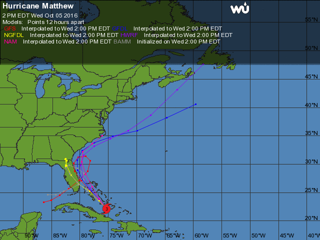
“We’ve gotten more consistent forecasts that it won’t hit us,” Rich said.  “The closest it is projected to Ocracoke is now 161 miles.”

In addition, storm surge is expected to be only one to two feet, down from an earlier prediction of one to three feet, he said.

Ferries to and from the island are on schedule tomorrow, though the Ferry Division had declared yesterday that ferry service to and from the island will cease at first light on Friday.  Those residents who want to leave the island should do so on Thursday, Rich said, but the Ferry Division also will revisit that declaration tomorrow, Rich said.  

Ferries will run tomorrow according to their published scheduler, Rich said.

The Control Group, composed of various county and law enforcement officials and business owners to recommend actions in emergencies, will meet again tomorrow morning at 11, Rich said.

Earlier, Hyde County Emergency Services issued a notice saying that most forecast models now predict the Atlantic high pressure ridge will keep Matthew to the South.  

That is still the case, Rich said.

“The maximum sustained winds are projected at 25 to 35 knots, if it stays as it is,” Rich said. “That’s like a nor’easter.”

The latest tracks shows the storm turning east into the Atlantic before it reaches the North Carolina coast, according to the National Hurricane Center. 

Hyde County will continue to monitor the situation and will make decisions on suspension of this evacuation order as the forecast path becomes more certain.

Ocracoke School will be closed on Thursday and Friday and the National Park Service has all of its operations closed on Ocracoke for the time being.

Dr. Jeff Masters of the Weather Underground includes this in his posting today:

Track forecast for Matthew: danger to North Carolina and New England lessens

Wednesday’s latest 00Z run of the European model and 06Z run of the GFS model predicted that Matthew would turn to the northeast and then east on Saturday, keeping the storm several hundred miles south of the coast of North Carolina. In this scenario, the coasts of Georgia and southern South Carolina might still be at risk of hurricane force winds, but the coast farther north—including New England and Canada—would not be. In their 11 a.m. Wednesday Wind Probability Forecast, NHC was giving the coast from Jacksonville, Florida to Charleston, South Carolina 10 to 16 percent chances of receiving hurricane force winds. Probabilities for the coast of North Carolina were less than 10 percent.

at201614_model

NOAA forecast today shows Matthew threat to Ocracoke diminishing

0
at201614_model
Image courtesy of Weather Underground

The Hyde County Commissioners on Tuesday afternoon ordered mandatory evacuation of visitors and residents of the island starting today for visitors and residents tomorrow in advance of the expected arrival of Hurricane Matthew. Click here for an earlier story.

Overnight, the expected track changed lessening the likelihood of  a major hurricane strike on Ocracoke. Any changes in the storm direction or a change in the evacuation status will be reported.

From the National Weather Service
Newport/Morehead City, N.C.

Oct. 5, 2016, 5 a.m.

A significant model forecast change in the track of Matthew continues to develop. This has increased uncertainty and the confidence in the forecast threat level for the area is lower. The majority of models now keep the center of Matthew off the coast and actually curve it back to the south.  Some models still indicate a track closer to or over Eastern N.C.

  • The updated National Hurricane Center forecast takes this into account and shifts the track significantly off the coast. The forecast now keeps the center of Matthew off our coast to the south and east, reducing impacts for our area.

 The threat of dangerous life threatening conditions has diminished with the new forecast track, but we urge continued caution across Eastern NC. We are hopeful this model trend continues and the most significant impacts are not realized in Eastern NC. However it is too early to completely let our guard down.  It is still within the margin of error for the storm to pass very close to or over our coastal areas.

  • Continue to monitor the forecast for future. Have a disaster preparedness kit ready, and plans for what you would do if asked to evacuate.

Hurricane Matthew key points:

 Based on the new model trends, the now most likely impacts on Eastern NC will be:

  • Minor to moderate storm surge and high surf
  • Tropical storm force winds that could produce minor damage along the
  • Heavy rainfall and flash flooding is still possible
  • Extremely dangerous conditions for Rip currents

 Closely monitor the forecast for Matthew in the coming days. Be alert to additional forecast track changes that could increase the danger to our area.  Be prepared to take action to protect yourself and your property if needed

For Ocracoke news, click here.

National Park Service visitor services suspended on Ocracoke Island

0
NPS Visitors Center 2016
The NPS Visitors Center on Ocracoke is closed today due to the evacuation in anticipation of Hurricane Matthew. Photo: C. Leinbach

The Outer Banks Group continues to closely monitor the path of Hurricane Matthew. Due to Hyde County’s mandatory visitor evacuation of Ocracoke Island that began at 5 a.m. today, National Park Service (NPS) visitor services on Ocracoke will be fully suspended by the end of today.

Campgrounds: The Ocracoke Campground closed at 10 a.m. today. Oregon Inlet, Cape Point, and Frisco campgrounds continue to operate on a one-day availability basis.

Visitor Services: The NPS  visitor center and off-road vehicle permit office on Ocracoke Island will not open today, and will stay closed until further notice. NPS visitor services may be suspended on Hatteras Island, Bodie Island, at Fort Raleigh National Historic Site and at Wright Brothers National Memorial on Thursday. Additional information will be sent out once Outer Banks Group management has made a determination based on current storm forecast. The parks’ social media sites on Facebook and Twitter will also be updated with current information.

Beach Access Ramps: All off-road vehicle beach access ramps on Ocracoke Island will be closed to vehicles by the end of today. Daily beach access ramp status updates are posted on the Cape Hatteras National Seashore Facebook page at http://facebook.com/capehatterasns.

Rip Currents: There is a high risk of dangerous rip currents, a high surf advisory, and rough surf north of Cape Hatteras today. A high risk of rip currents will continue throughout the storm period. For more information on rip currents safety go to http://www.ripcurrents.noaa.gov.

For Ocracoke news, click here.

NC Ferry Division assisting with Ocracoke evacuation

0
Beautiful sunsets are frequent backdrops on ferry rides to and from Ocracoke. This view was taken on the Swan Quarter ferry heading toward Ocracoke. Photo: C. Leinbach

For Ocracoke news, click here.

From the N.C. Ferry Division Oct. 4, 2016  10:54 p.m.

MANNS HARBOR – As Hurricane Matthew approaches, the N.C. Department of Transportation’s Ferry Division is assisting with the phased evacuation of Ocracoke Island.  Hyde County issued a mandatory evacuation order for island visitors beginning at 5 a.m. Wednesday, Oct. 5, to be followed by a mandatory evacuation for all residents at 5 a.m. Thursday, Oct. 6.

On Wednesday, only residents, property owners, vendors, and critical infrastructure providers with Ocracoke re-entry documentation will be allowed on ferries inbound to Ocracoke. On Thursday, only emergency personnel and vendors will be allowed onto the island.

Priority boarding will be suspended for all vessels leaving Ocracoke Wednesday morning and tolls will be waived for ferries heading from Ocracoke to Cedar Island or Swan Quarter.  All ferry service to and from Ocracoke will end Thursday night at midnight, to allow all ferries and ferry personnel to find safe harbor from the storm.

“Safety is our first priority, and we hope all of Ocracoke’s visitors and residents take this storm seriously and evacuate as soon as they can,” said Ferry Division Assistant Director Jed Dixon. “Hurricane Matthew has already shown its destructive potential, and everyone on Ocracoke should make plans to get out of its path.”

Gov. Pat McCrory declared a state of emergency on Monday, urging residents and visitors to be prepared for heavy rain, flooding, and the possibility of hurricane-force winds when Matthew passes through the state over the weekend.

Evacuation procedures will remain in effect for all Ocracoke-bound ferries until Hyde County emergency officials lift the evacuation order.


Evacuation ordered for Ocracoke in advance of Hurricane Matthew

2
Silver Lake Harbor is already at extremely high water levels not related to Hurricane Matthew. Photo by P. Vankevich
Silver Lake Harbor is already at extremely high water levels, not related to Hurricane Matthew. Photo by P. Vankevich

Oct. 4, 2016

The Hyde County Commissioners on Tuesday afternoon ordered mandatory evacuation of visitors and residents of the island starting tomorrow (Wednesday) in advance of the arrival of Hurricane Matthew.

Visitors must begin evacuating starting at 5 a.m., according to Bill Rich, Hyde County manager.

Resident and non-resident property owners, vendors and critical infrastructure providers will be permitted to travel to and from the island 

Starting at 5 a.m. Thursday, island residents are required to leave.   Only emergency personnel and vendors will be granted access to the island on Thursday, Rich said.

The N.C. Ferry Division will stop running ferries on Friday so that they can have all day to secure their boats, Rich said.

The Hyde County Emergency Services Department is monitoring Hurricane Matthew. Hurricane Matthew is forecast to be a Category Two Hurricane that has the potential to pass through or very near to Eastern North Carolina.

The following is from a Hyde County advisory:

The Hyde County Emergency Services Department is monitoring Hurricane Matthew, which is forecast to be a Category Two hurricane that has the potential to pass through or very near to Eastern North Carolina. This is a storm that should be taken very seriously for its potential to result in catastrophic impacts for portions of the area. Regardless of exact track or strength there is the potential for dangerous and life threatening impacts across the entire area.

Matthew has the potential to make landfall in South Carolina or North Carolina sometime between Friday and Sunday. Matthew is forecast to bring dangerous and potentially life-threatening storm surge and high surf, damaging strong winds that could produce prolonged power outages, heavy rainfall and flash flooding, tornadoes, extremely dangerous conditions for boaters and rip currents.

This is a storm that should be taken very seriously for its potential to result in catastrophic impacts for portions of the area, according to a Hyde County press release. Regardless of exact track or strength, there is the potential for dangerous and life-threatening impacts across the entire area.

Closely monitor the forecast for Matthew in the coming days, and be prepared to take action to protect yourself and your property. Secure your home. Board up windows and secure lawn furniture, mowers, hanging plants, trash cans and other loose items in the yard. Check on your neighbors, particularly the elderly or disabled.

Make plans now for how you will deal with the potential threats and impacts. Your plans and preparedness measures should include:

  • Have a disaster preparedness kit ready, and take your emergency supplies kit with you when you evacuate.
  • Pack important family documents in a waterproof container.
  • Have a place to go, such as the home of a family member or friend, motel or shelter.
  • Notify family or friends of your plans, when you are leaving and where you are going.
  • Be familiar with area’s evacuation routes.
  • Fill your car with gas.
  • Bring extra cash as banks may be closed and ATMs may not work.
  • Do not panic.
  • Arrive safely at your destination.

Please be advised, flood waters may contain sewage and other harmful contaminants. Keep children and pets out of flood waters.

For Ocracoke news, click here.


Body of missing swimmer found south of CHNS Ramp 23

0

Oct. 4, 2016

The body of a 55-year-old male caught in a rip current and pulled into the ocean off a Cape Hatteras National Seashore beach in Salvo on Oct. 2 was found this morning just south of Ramp 23 in the Salvo area, according to Outer Banks Group Superintendent David Hallac.

A park visitor reported it this morning at 7:36 a.m.

 Chicamacomico Banks Water Rescue and the United States Coast Guard had responded quickly on Oct. 2, but were unable to locate the swimmer.  The Park Service has not released the name of the swimmer.

 “We extend our thoughts and condolences to his family and friends,” Hallac said.

The National Weather Service reports that there is currently a moderate-to-high risk of dangerous rip currents along Cape Hatteras National Seashore beaches during this storm period. For more information on rip currents safety go to http://www.ripcurrents.noaa.gov.

For an Observer story on rip currents and what kind of water to look for, click here.

New works by Melinda Fodrie Sutton on view tomorrow in Down Creek Gallery

0
'Soundside View' by Melinda Fodrie Sutton will be among the new works on view starting tomorrow in Down Creek Gallery.
‘Soundside View’ by Melinda Fodrie Sutton will be among the new works on view starting tomorrow in Down Creek Gallery.

Update Oct. 5: The opening reception scheduled for tonight has been postponed until the same time on Oct. 26.

New work by island photographer Melinda Fodrie Sutton will highlight the final Expose Yourself to Art series of artists’ receptions from 5 to 8 p.m. Wednesday, Oct. 26, in Down Creek Gallery.

All are welcome to attend.  Music by Raygun Ruby will complement the light hors d’ oeuvres and adult beverages.

While Sutton is noted for her vibrant island scenes, the gallery will show some of her recent work focusing on structures and buildings.

She and her husband Alan Sutton, own Tradewinds Tackle here, and Sutton began exploring her passion for photography several years ago.

She has now been featured at Down Creek Gallery, several Ocracoke business and restaurants, and in Charleston, S.C, and Chicago, Ill.

For the last three years, Sutton’s camera has focused on the ever-changing island landscape.

“I love walking and taking pictures,” she said. “I see the world differently.” 

Melinda Fodrie Sutton

So began her therapeutic “walk-about” period–10,000 steps a day with her iPhone camera in her pocket.  Photo sharing on Facebook led to enthusiastic feedback from friends liking this new direction. 

Encouraged to pursue photography more seriously, she enrolled in a four-week class in landscape photography at the University of South Carolina, Charleston.

“There are many things I want to do creatively, and I want to travel and see other countries and cultures,” she said.

This year, Sutton embarked on new subject matter in structural images.  She will feature both framed and unframed pieces, many of which are black-and-white.

For Ocracoke news, click here.

Postponed due to weather: Red Clay Ramblers to perform

0
Red Clay Ramblers
Red Clay Ramblers

For Ocracoke news, click here.

Update  10/4/2016 4:59 p.m.: Due to the uncertainty on what Hurricane Matthew will deliver to the region, this concert has been postponed. A new date will be announced later. 

The Core Sound Waterfowl Museum & Heritage Center and the North Carolina Coastal Federation are teaming up to host the Tony Award-winning band, The Red Clay Ramblers, in a special two-night event, Oct. 7 and 8.

The North Carolina natives will be performing in Joslyn Hall at Carteret Community College. Doors will open at 7 p.m. with concerts beginning at 7:30 p.m. on both nights.

Tickets are $28 general admission, $23 for members (CSWM&HC and NC Coastal Federation), and $12 for students, and can be purchased by contacting Core Sound Museum at 252-728-1500.

The string band’s music draws from multiple genres, including “old-time mountain music,” as well as bluegrass, country rock, New Orleans jazz, gospel and the “American musical” to from its eclectic sound and unique taste.

Since their formation in 1972, Ramblers have performed on various stages throughout the world. Some of those stages consist of several local appearances through the years, including performances at Croatan High School, the Core Sound Waterfowl Museum & Heritage Center, and the Coastal Folklife Project in Beaufort.

Personnel for The Ramblers’ October performances will include Clay Buckner on the fiddle, Chris Frank on the guitar, Jack Herrick on the trumpet and bass, Rob Ladd on the drums, and Bland Simpson on the piano.

Simpson has visited Ocracoke and performed here earlier this year.

The musical group is noted as being high energy with a wide-ranging repertoire.  

“Bluegrass, New Orleans, classical folk, and gospel sounds emerge in nutty profusion from these talented instrumentalists and singers, whose music making is perfection,” states The New York Times.

Both the Core Sound Waterfowl Museum & Heritage Center and the North Carolina Coastal Federation are preparing for milestone years in 2017. The CSWM&HC will celebrate its 25th anniversary, while the NC Coastal Federation celebrates its 35th anniversary.

Both presenters have big things planned in observance of these significantly historic years. “These are two truly fine, highly significant groups, not only for Carteret County but for the whole state of North Carolina,” Simpson said. “Both of them exemplify the very best values in preserving, protecting, and celebrating our social and natural heritage here on the coast. We are thrilled to be making a joyful noise for them in Morehead City this fall.”

Ocracoke judo team produces three state champions; all members receive medals

0
judo-team
All members of the Ocracoke judo team on Saturday won medals with three members achieving state champion in the N.C. State Judo Tournament in Waynesville. Back row, from left, Gustavo Sanchez, Christian Stevens, Russell Stevens, Casey Robertson and Jetta Brown. Front row, from left, Baily Bryan, Alyssa Bryan and Sally Jordan.

For Ocracoke news, click here.

By Connie Leinbach

The Ocracoke Judo team has put Ocracoke on the map after all eight team members won medals—with three state champions–Saturday in the North Carolina State Judo Tournament in Waynesville.

“We came to do a job and we did it,” said Gustavo Sanchez, owner and sensei of Ocracoke Judo as they drove back to the island.

Seven of the team won two medals each, and new state judo champions with gold medals are Baily Bryan (9 to 10), Christian Stevens (11 to 12) and Sally Jordan (9 to 10), who each won gold medals in their divisions.

Baily and Christian also won bronze medals and Baily also won a silver medal.

The Ocracoke team huddles before the action begins. Photo by Ruth Jordan.

Alyssa Bryan won silver and bronze medals, and Russell Stevens won a silver medal.

In the adult division, Casey Robertson won silver and bronze medals; Jetta Brown won two silver medals and Sanchez won two bronze medals.

The tournament, called “The Fall Brawl,” was held in the Waynesville Recreation Center.

“They looked fantastic,” said Helena Stevens Saturday night after the victories. She accompanied the group with her sons, Christian and Russell.

judo tournament
Christian Stevens, right, receives his medal. Photo by Helena Stevens

Stevens said the other competitors were bigger and stronger, but the Ocracoke group was ready.

Participating in the tournament gave them the opportunity to test their skills on other judo  students, she said. 

“It gave them motivation,” she said. “They’ve never competed before, but they came and they achieved.”

Sanchez said this tournament was a lot smaller than the ones his former dojo in Bakersfield, Calif., competed in where there were 600 or 700 competitors.

As a result, some of the Ocracoke team members also competed in higher weight divisions.

“Casey and Jetta were fighting black belts,” he said, noting that the two are green belts, or novices. “All of the other kids had experience in competition, and for us, it was the first time ever.”

judo tourney
Sally Jordan, left, in competition Saturday in the N.C. State Judo Tournament. Photo by Helena Stevens


Brown said she learned a lot in her first tournament.

“They had different styles (of fighting),” she said about her competitors. “But they were really nice even though we beat each other up.”

Sanchez said the officials and competitors were friendly, and some had never heard of Ocracoke.

“They were very excited to have Ocracoke in the tournament,” he said.

During his final bout, Sanchez said he slightly twisted his knee and withdrew, though he still achieved the bronze medal.

He will compete in the world tournament in Nov. 16 in Ft. Lauderdale, Fla., and did not want to have to withdraw from that.  He will leave Oct. 9 for Bogota, Columbia, South America, to train with his own sensei lives and where he first learned the sport.

One of the keys to the Ocracoke team’s success, besides a lot of training, is mental preparedness, Sanchez said.

“Mental preparation prevents injuries,” he said on Friday on the Swan Quarter ferry as the group headed to the far western end of the state. “By (your) mentality, you can win or lose. Lack of concentration leads to injuries. Judo changes your life. You have to do things in order and do them well.”

Sanchez said the team is creating a reputation at the state level.

“Now we have to maintain and grow to the national level,” he said.


Judo tournament
Ocracoke team member Christian Stevens in action Saturday at the N.C. State Judo Tournament in the Waynesville recreation Center. Photo by Helena Stevens


For past stories on Judo on Ocracoke, click here,   here , and here.

Hurricane Matthew heading toward Cuba, Haiti and Jamaica; Ocracokers wary

0


hurricane-matthew


Hurricane Matthew briefly was classified at a Category 5 (exceeding 156 mph)–the highest level–making it one of the most powerful hurricanes since Felix in 2007.   Now a Category 4 (maximum sustained winds of 130-156 mph)), it stalled on Saturday but has started a northward trend as expected.

The latest projections show Matthew’s center likely to strike the southwestern tip of Haiti on Monday. A hurricane warning has been issued for the impoverished country which shares the island of Hispaniola with the Dominican Republic.  It will continue moving north through the Bahamas.

There remains at this early stage a lot of  uncertainty according to several tracking models as to whether there will be a direct strike in the Carolinas, or veer off to sea.

The expected time to  reach the general latitudes of the the Carolinas is Friday into Saturday, and more detailed information will be known within the next 24 to 48 hours.

Locally, dangerous rip currents and high surf are affecting the area according to the NWS Forecast Office Newport/Morehead City, N.C.

Many islanders voiced concerns about the potential for serious flooding since the island has recently received a lot of rain and the water levels in Silver Lake Harbor and the sound are already very high.

Although bird nesting is over there remains many turtle nests with unhatched eggs that could be wiped out.

The following was posted by the Hyde County Emergency Services today and  more updates will be forthcoming in the following days.

POWERFUL HURRICANE MATTHEW MEANDERING BUT EXPECTED TO MOVE NORTHWESTWARD TO NORTHWARD…

Hurricane Matthew has essentially stalled in the Central Caribbean, moving erratically over the past 24 hours. Matthew is currently moving west at 3 mph and located approximately 347 miles southwest of Port-au-Prince (14.0°N 74.6°W), which only about 13 miles closer to Haiti than is was at this time yesterday. The hurricane is forecast to continue a northwestward to northward forward motion at some point today.

Currently, Matthew is a Category 4 with 140 mph maximum sustained winds. The eye of Matthew has become obscured on visible satellite images, which is often an indication of weakening. Microwave images showed a distinct dry slot over the southwestern and western portions of the circulation. Also there has been a persistent, but inexplicable, cluster of deep convection located a couple of degrees to the east of the hurricane and the effect of this feature on Matthew’s intensity evolution is unknown. Additionally, since the storm has essentially been stationary, the upwelling of cooler water could also be a factor contributing to the observed weakening. The NHC expects steady weakening over the next five days, as indicated by the max wind speed forecast published at 11 a.m.

Short-term forecast

Despite Matthew drifting a bit further westward than expected on Sunday morning, the models are very unified in their two-day track forecasts for Matthew.  A large upper-level low pressure system over east-central U.S. will pull Matthew to the north through Tuesday, resulting in a landfall or a near-miss in southwest Haiti on Monday night into Tuesday morning, followed by a second landfall in eastern Cuba/northwest Haiti on Tuesday morning. Matthew will then continue northwards into the southeastern Bahamas on Tuesday afternoon.

Long-term forecast

Matthew’s anticipated landfall over Jamaica/Cuba/Haiti on Monday into Tuesday will weaken the storm, due to the high mountains it will interact with. However, it now appears that Matthew will have limited time over land, due to the storm’s expected track mostly over the water areas between Haiti and Cuba. Matthew’s inner core may be able to survive the land interaction, resulting in a much stronger storm in the Bahamas. Matthew is likely to be a major Category 3 or stronger hurricane for at least a portion of its trek through the Bahamas. As Matthew moves north of the Bahamas, waters will cool and the shear is likely to increase, resulting in some weakening late next week.

Local emergency protective measures

The Hyde County Emergency Services Department will continue to monitor the forecast and issue internal advisories as appropriate. Given the current forecast timing, serious discussions regarding emergency preparations and protective measures may begin as early as Monday. Matthew is a very dangerous storm and given current conditions, it could pose a significant threat to Eastern North Carolina.