The roiling surf around noon today at the Lifeguard Beach on Ocracoke. Photo: C. Leinbach
Oct. 7, 2016; 2:21 p.m.
Ocracoke evacuation nearing completion; Hatteras to shut down Saturday
MANNS HARBOR – Due to the approach of Hurricane Matthew, the N.C. Department of Transportation’s Ferry Division will suspend operations to and from Ocracoke Island on Pamlico Sound routes after the 4 p.m. departure from Ocracoke to Cedar Island today (Friday, Oct. 7).
The final run from Ocracoke to Swan Quarter departed at 1:30 p.m. Ferry officials anticipate suspending operations on the Ocracoke-Hatteras route sometime Saturday morning.
“The time has come to secure our boats and get our crews out of harm’s way,” said Ferry Division Deputy Director Jed Dixon. “Anyone still wishing to leave Ocracoke Island before Hurricane Matthew arrives should do so immediately.”
So far, the North Carolina Ferry System has evacuated more than 1,350 people from Ocracoke on the three routes.
Ferry Division managers will monitor weather conditions and resume service as soon as it is safe to do so.
For real-time updates, follow the Ferry Division on Twitter at @NCDOT_Ferry.
Ocracoke’s usually busy main street, Irvin Garrish Highway, is practically deserted Wednesday as the evacuation of visitors had begun. Today it is raining with more photos to follow. Photo: C. Leinbach
Updated noon, Oct. 7, 2016
Today’s (Oct. 7) forecast brings back the potential for a very dangerous and life threatening situation for all of Eastern N.C., according to an 8 a.m. report issued by Richard S. Bandy, meteorologist-in-charge, National Weather Service Weather Forecast Office Newport/Morehead City. (See link to full report below which says this could be the worst flooding sinceHurricane Floyd.)
“Extremely heavy rainfall combined with storm surge/coastal flooding will result in the potential for widespread and deep flash flooding mixing with storm surge/coastal flooding and river flooding,” Bandy said. “The wind forecast has increased along the coast as well, so more numerous issues with downed trees and power outages can be expected.”
Ferries to and from the Ocracoke are running. The long routes to Cedar Island and Swan Quarter are on schedule, and a modified schedule for the Ocracoke-Hatteras run is also running. Click here for that schedule.
The Hyde County Board of Commissioners will meet with the Ocracoke Control Group at 2 p.m. today (Oct. 7), and the Hyde County government offices will close today at 3 p.m. due to inclement weather and flooding of roadways.
Hyde County Emergency Services is now using a system called Hyper-Reach to provide a way to send alerts to our residents. You can choose to receive weather related alerts, community alerts or both. The alerts can be delivered via phone call, text message and email. We highly recommend that everyone register with this service. Just click on theattached link.
Outer Banks Group (Cape Hatteras National Seashore) update:
By 5 p.m. today, all visitor services and facilities at Cape Hatteras National Seashore, Fort Raleigh National Historic Site, and Wright Brothers National Memorial will be closed until further notice.
All campgrounds closed at 10 a.m. today.
All Cape Hatteras National Seashore ORV ramps will be closed to vehicle traffic by 4 p..m. today.
Visitor services and facilities will reopen after post-storm assessments are completed.
Tideland Electric Membership Cooperative sent extra materials over earlier this week and an extra bucket truck yesterday,, said spokesperson Heidi Smith. “Additional crews will be staged in Washington until we know if and where we will be impacted,” she said. “Right now, our Pamlico and Craven county service territories appear to be most susceptible to outages.” Already, an extra seven-man crew staying in Fairfield where they are working on a construction job for the electric company, but have been told they could be activated for storm duty should the need arise. “As we get closer, it is still possible that we would dispatch additional personnel to the island if the forecast significantly changes,” Smith said.
The Ocracoke Planning Advisory Board meeting has been rescheduled to Nov. 10 and the Ocracoke Board of Adjustment (variance board) meeting has been postponed to Nov. 11.
Luana Gibbs, Hyde County acting health director, meets islanders in the conference room of the Ocracoke Volunteer Fire Dept. Photo: C. Leinbach
The Hyde County Health Dept. is here for everyone, said Interim Director Luana Gibbs when she was on Ocracoke recently for a meet-and-greet.
“It’s all about community,” Gibbs said between greeting islanders in the first-floor meeting room of the Ocracoke Volunteer Fire Department. “Education is a big piece of public health.”
The Health Department, located in Swan Quarter, is a working health clinic open weekdays from 8 a.m. to 5 p.m. While they perform pre-natal care, family planning, sexually transmitted disease screening and treatment, they also handle many other medical issues.
Kelley Newman is the nurse practitioner there, Gibbs said.
All fees are based on a sliding fee scale and they accept many of the major insurance plans.
“We’re not just there for the indigent,” she said. “We’re there for everyone.”
Gibbs said that Hydeland Health, the home health provider, is in the process of being sold to Liberty, which also owns the Cross Creek nursing home in Swan Quarter.
“If you need home health care, your doctor orders it,” she said.
She also said hospice care in the county has resumed under the auspices of Amedisys of Plymouth.
Gibbs, a registered nurse, has worked in the health department for many years.
“I thoroughly love it,” she said about her new responsibilities.
She is pursuing an undergraduate degree in interdisciplinary studies with a concentration on nonprofit administration.
After she completes that, she will have the credentials to become the actual health director.
For more Hyde County Health Dept. information, click here.
Frequent island visitor Mary Bedwell of Memphis, Tenn., captured this stunning shot of the Swan Quarter ferry on Oct. 2
The following is from Hyde County Emergency Services, issued at 2 p.m., Thursday, Oct. 6, 2016.
In a change from a previous decision, the N.C. Ferry Division will run a limited schedule on the Hatteras-Ocracoke ferry route tomorrow (Friday). Departures are as follows:
In anticipation of Hurricane Matthew heading for the North Carolina coast, the Ferry Division previously had announced it would suspend runs at first light Friday.
However, tomorrow, the division will move several vessels out of harm’s way as Hurricane Matthew moves closer to southeastern coast of North Carolina.
Today (Thursday), the Ferry Division will operate on a normal schedule as conditions allow. Water levels have been abnormally high over the past several days due to previous rainfall events and winds are already approaching speeds that could result in suspensions of service. Visitors are encouraged to evacuate as early as possible to ensure safe travels to their intended destinations.
As of today, Hyde County officials suspended the mandatory evacuation order issued for residents and non-resident property owners. Residents and non-resident property owners, vendors and critical infrastructure providers will be permitted to travel to and from the island until ferry service is suspended. Please be prepared to show documentation of the aforementioned statuses to gain access to the island. Individuals wishing to gain access will need to have the appropriate re-entry tag or they will be required to produce evidence of property ownership or residency.
Even though the forecast has changed significantly, the visitor evacuation orders are still necessary and the evacuation has proceeded smoothly, according to the NCDOT Ferry Division. As of 5 a.m. this morning, the Ferry Division reported moving 1,095 people off island. The mandatory evacuation for Ocracoke Island visitors will remain in effect until conditions can be assessed after the event. The County of Hyde will work expeditiously to restore visitor access to Ocracoke Island, as the conditions permit.
The model trends that show Matthew off the coast have been consistent over the past day, and the latest National Hurricane Center forecast has maintained a track which curves back south of the North Carolina coast.
The threat of dangerous and life threatening conditions diminishes with each favorable track update, but officials urge continued caution across the county.
According to Hyde County Emergency Management Services, based on the current official forecast, the most likely impacts for Eastern NC will be:
Minor to moderate storm surge and ocean side wave run-up issues resulting in minor to moderate erosion and isolated areas of over wash.
The potential for tropical storm force winds along the southern coast.
Heavy rainfall and isolated flash flooding is still possible
Extremely dangerous conditions for boaters.
Rip currents
We are hopeful the favorable forecast trends continue and the most significant impacts are not realized in Eastern NC. However it is too early to completely let our guard down. It is still within the margin of error for the storm to pass closer to the coast which would increase the impacts across coastal areas and inland. Continue to monitor the forecast for future changes.
Based on the current forecast, a mandatory evacuation for mainland Hyde County is not expected.
Access to the beach via vehicles remains closed today, but pedestrians can still visit the beach at the Day Use area and other locations on the island. Photo: C. Leinbach
Oct. 6, 2016 From the Cape Hatteras National Seashore:
Given the current predictions for the track of Hurricane Matthew, Fort Raleigh National Historic Site, Wright Brothers National Memorial, and much of Cape Hatteras National Seashore will remain open today. Because of the continued Hyde County mandatory visitor evacuation of Ocracoke Island, National Park Service (NPS) visitor services on Ocracoke will remain closed today.
Campgrounds: The Ocracoke Campground will remain closed. Oregon Inlet, Cape Point and Frisco campgrounds continue to operate on a one-day availability basis.
Visitor Services: The NPS visitor center and off-road vehicle permit office on Ocracoke will not open today, and will stay closed until further notice. NPS visitor services on Hatteras Island, Bodie Island, at Fort Raleigh National Historic Site and at Wright Brothers National Memorial will remain open today.
Lighthouses: Cape Hatteras Lighthouse and Bodie Island Lighthouse will remain open today. As always, the opportunity to climb the lighthouses will depend on wind speeds.
Beach Access Ramps: All off-road vehicle beach access ramps on Ocracoke remain closed to vehicles today. Daily beach access ramp status updates are posted on the Cape Hatteras National Seashore Facebook page athttp://facebook.com/capehatterasns.
Rip Currents: There is a high risk of dangerous rip currents on all park beaches, a high surf advisory, and rough surf north of Cape Hatteras today. A high risk of rip currents will continue throughout the storm period. For more information on rip currents safety go tohttp://www.ripcurrents.noaa.gov.
Hyde County today suspended the mandatory evacuation tomorrow (Thursday) for Ocracoke residents that had been declared Wednesday.
Bill Rich, Hyde County manager, reported from the 5 p.m. meeting of the Ocracoke Deputy Control Group, that the suspension was made in light of the diminished threat to North Carolina by Hurricane Matthew. The evacuation order for residents is not “rescinded,” only suspended, which means that if conditions change, the evacuation order could be reinstated without another official evacuation declaration.
Resident and non-resident property owners, vendors and critical infrastructure providers will be permitted to travel to and from the island tomorrow and should be prepared to show documentation of property ownership or residency to gain access to the island.
Evacuation orders are still in effect for visitors, who were ordered to leave starting at 5 a.m. Wednesday, he said.
“We’ve gotten more consistent forecasts that it won’t hit us,” Rich said. “The closest it is projected to Ocracoke is now 161 miles.”
In addition, storm surge is expected to be only one to two feet, down from an earlier prediction of one to three feet, he said.
Ferries to and from the island are on schedule tomorrow, though the Ferry Division had declared yesterday that ferry service to and from the island will cease at first light on Friday. Those residents who want to leave the island should do so on Thursday, Rich said, but the Ferry Division also will revisit that declaration tomorrow, Rich said.
Ferries will run tomorrow according to their published scheduler, Rich said.
The Control Group, composed of various county and law enforcement officials and business owners to recommend actions in emergencies, will meet again tomorrow morning at 11, Rich said.
Earlier, Hyde County Emergency Services issued a notice saying that most forecast models now predict the Atlantic high pressure ridge will keep Matthew to the South.
That is still the case, Rich said.
“The maximum sustained winds are projected at 25 to 35 knots, if it stays as it is,” Rich said. “That’s like a nor’easter.”
The latest tracks shows the storm turning east into the Atlantic before it reaches the North Carolina coast, according to the National Hurricane Center.
Hyde County will continue to monitor the situation and will make decisions on suspension of this evacuation order as the forecast path becomes more certain.
Ocracoke School will be closed on Thursday and Friday and the National Park Service has all of its operations closed on Ocracoke for the time being.
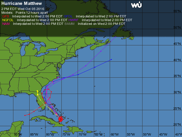
Dr. Jeff Masters of the Weather Underground includes this in his posting today:
Track forecast for Matthew: danger to North Carolina and New England lessens
Wednesday’s latest 00Z run of the European model and 06Z run of the GFS model predicted that Matthew would turn to the northeast and then east on Saturday, keeping the storm several hundred miles south of the coast of North Carolina. In this scenario, the coasts of Georgia and southern South Carolina might still be at risk of hurricane force winds, but the coast farther north—including New England and Canada—would not be. In their 11 a.m. Wednesday Wind Probability Forecast, NHC was giving the coast from Jacksonville, Florida to Charleston, South Carolina 10 to 16 percent chances of receiving hurricane force winds. Probabilities for the coast of North Carolina were less than 10 percent.
The Hyde County Commissioners on Tuesday afternoon ordered mandatory evacuation of visitors and residents of the island starting today for visitors and residents tomorrow in advance of the expected arrival of Hurricane Matthew. Click here for an earlier story.
Overnight, the expected track changed lessening the likelihood of a major hurricane strike on Ocracoke. Any changes in the storm direction or a change in the evacuation status will be reported.
From the National Weather Service Newport/Morehead City, N.C.
Oct. 5, 2016, 5 a.m.
A significant model forecast change in the track of Matthew continues to develop. This has increased uncertainty and the confidence in the forecast threat level for the area is lower. The majority of models now keep the center of Matthew off the coast and actually curve it back to the south. Some models still indicate a track closer to or over Eastern N.C.
The updated National Hurricane Center forecast takes this into account and shifts the track significantly off the coast. The forecast now keeps the center of Matthew off our coast to the south and east, reducing impacts for our area.
The threat of dangerous life threatening conditions has diminished with the new forecast track, but we urge continued caution across Eastern NC. We are hopeful this model trend continues and the most significant impacts are not realized in Eastern NC. However it is too early to completely let our guard down. It is still within the margin of error for the storm to pass very close to or over our coastal areas.
Continue to monitor the forecast for future. Have a disaster preparedness kit ready, and plans for what you would do if asked to evacuate.
Hurricane Matthew key points:
Based on the new model trends, the now most likely impacts on Eastern NC will be:
Minor to moderate storm surge and high surf
Tropical storm force winds that could produce minor damage along the
Heavy rainfall and flash flooding is still possible
Extremely dangerous conditions for Rip currents
Closely monitor the forecast for Matthew in the coming days. Be alert to additional forecast track changes that could increase the danger to our area. Be prepared to take action to protect yourself and your property if needed
The NPS Visitors Center on Ocracoke is closed today due to the evacuation in anticipation of Hurricane Matthew. Photo: C. Leinbach
The Outer Banks Group continues to closely monitor the path of Hurricane Matthew. Due to Hyde County’s mandatory visitor evacuation of Ocracoke Island that began at 5 a.m. today, National Park Service (NPS) visitor services on Ocracoke will be fully suspended by the end of today.
Campgrounds: The Ocracoke Campground closed at 10 a.m. today. Oregon Inlet, Cape Point, and Frisco campgrounds continue to operate on a one-day availability basis.
Visitor Services: The NPS visitor center and off-road vehicle permit office on Ocracoke Island will not open today, and will stay closed until further notice. NPS visitor services may be suspended on Hatteras Island, Bodie Island, at Fort Raleigh National Historic Site and at Wright Brothers National Memorial on Thursday. Additional information will be sent out once Outer Banks Group management has made a determination based on current storm forecast. The parks’ social media sites on Facebook and Twitter will also be updated with current information.
Beach Access Ramps: All off-road vehicle beach access ramps on Ocracoke Island will be closed to vehicles by the end of today. Dailybeach access ramp status updates are posted on the Cape Hatteras National Seashore Facebook page athttp://facebook.com/capehatterasns.
Rip Currents: There is a high risk of dangerous rip currents, a high surf advisory, and rough surf north of Cape Hatteras today. A high risk of rip currents will continue throughout the storm period. For more information on rip currents safety go tohttp://www.ripcurrents.noaa.gov.
Beautiful sunsets are frequent backdrops on ferry rides to and from Ocracoke. This view was taken on the Swan Quarter ferry heading toward Ocracoke. Photo: C. Leinbach
From the N.C. Ferry Division Oct. 4, 2016 10:54 p.m.
MANNS HARBOR – As Hurricane Matthew approaches, the N.C. Department of Transportation’s Ferry Division is assisting with the phased evacuation of Ocracoke Island. Hyde County issued a mandatory evacuation order for island visitors beginning at 5 a.m. Wednesday, Oct. 5, to be followed by a mandatory evacuation for all residents at 5 a.m. Thursday, Oct. 6.
On Wednesday, only residents, property owners, vendors, and critical infrastructure providers with Ocracoke re-entry documentation will be allowed on ferries inbound to Ocracoke. On Thursday, only emergency personnel and vendors will be allowed onto the island.
Priority boarding will be suspended for all vessels leaving Ocracoke Wednesday morning and tolls will be waived for ferries heading from Ocracoke to Cedar Island or Swan Quarter. All ferry service to and from Ocracoke will end Thursday night at midnight, to allow all ferries and ferry personnel to find safe harbor from the storm.
“Safety is our first priority, and we hope all of Ocracoke’s visitors and residents take this storm seriously and evacuate as soon as they can,” said Ferry Division Assistant Director Jed Dixon. “Hurricane Matthew has already shown its destructive potential, and everyone on Ocracoke should make plans to get out of its path.”
Gov. Pat McCrory declared a state of emergency on Monday, urging residents and visitors to be prepared for heavy rain, flooding, and the possibility of hurricane-force winds when Matthew passes through the state over the weekend.
Evacuation procedures will remain in effect for all Ocracoke-bound ferries until Hyde County emergency officials lift the evacuation order.
Silver Lake Harbor is already at extremely high water levels, not related to Hurricane Matthew. Photo by P. Vankevich
Oct. 4, 2016
The Hyde County Commissioners on Tuesday afternoon ordered mandatory evacuation of visitors and residents of the island starting tomorrow (Wednesday) in advance of the arrival of Hurricane Matthew.
Visitors must begin evacuating starting at 5 a.m., according to Bill Rich, Hyde County manager.
Resident and non-resident property owners, vendors and critical infrastructure providers will be permitted to travel to and from the island
Starting at 5 a.m. Thursday, island residents are required to leave. Only emergency personnel and vendors will be granted access to the island on Thursday, Rich said.
The N.C. Ferry Division will stop running ferries on Friday so that they can have all day to secure their boats, Rich said.
The Hyde County Emergency Services Department is monitoring Hurricane Matthew. Hurricane Matthew is forecast to be a Category Two Hurricane that has the potential to pass through or very near to Eastern North Carolina.
The following is from a Hyde County advisory:
The Hyde County Emergency Services Department is monitoring Hurricane Matthew, which is forecast to be a Category Two hurricane that has the potential to pass through or very near to Eastern North Carolina. This is a storm that should be taken very seriously for its potential to result in catastrophic impacts for portions of the area. Regardless of exact track or strength there is the potential for dangerous and life threatening impacts across the entire area.
Matthew has the potential to make landfall in South Carolina or North Carolina sometime between Friday and Sunday. Matthew is forecast to bring dangerous and potentially life-threatening storm surge and high surf, damaging strong winds that could produce prolonged power outages, heavy rainfall and flash flooding, tornadoes, extremely dangerous conditions for boaters and rip currents.
This is a storm that should be taken very seriously for its potential to result in catastrophic impacts for portions of the area, according to a Hyde County press release. Regardless of exact track or strength, there is the potential for dangerous and life-threatening impacts across the entire area.
Closely monitor the forecast for Matthew in the coming days, and be prepared to take action to protect yourself and your property. Secure your home. Board up windows and secure lawn furniture, mowers, hanging plants, trash cans and other loose items in the yard. Check on your neighbors, particularly the elderly or disabled.
Make plans now for how you will deal with the potential threats and impacts. Your plans and preparedness measures should include:
Have a disaster preparedness kit ready, and take your emergency supplies kit with you when you evacuate.
Pack important family documents in a waterproof container.
Have a place to go, such as the home of a family member or friend, motel or shelter.
Notify family or friends of your plans, when you are leaving and where you are going.
Be familiar with area’s evacuation routes.
Fill your car with gas.
Bring extra cash as banks may be closed and ATMs may not work.
Do not panic.
Arrive safely at your destination.
Please be advised, flood waters may contain sewage and other harmful contaminants. Keep children and pets out of flood waters.