A waterman. Photo courtesy of the Ocracoke Working Watermen’s Association.
The Ocracoke Preservation Society will celebrate the island’s tradition of working on the water with the First Annual Ocracoke Working Waterman’s Festival from 9 a.m. to 4 p.m. Saturday, Oct. 21, on the grounds of the Ocracoke Preservation Society Museum.
Since the first inhabitants of the island, Ocracokers have made their living on the water, from piloting ships through the treacherous Ocracoke Inlet, to fishing, crabbing, clamming, oyster harvesting, duck hunting, and decoy carving, all of which continue today, handed down through the generations.
The festival will celebrate these traditions with booths and exhibits with the watermen themselves. Porch talks will start at 10 a.m.. A silent auction will run from 9 a.m. until 3 p.m., at which time winners will be announced (If anyone would like to donate, they can drop off items at the museum until the day of).
A raffle for a ship-in-a-bottle by Jim Goodwin will be drawn at 3:30 p.m.. There will be a traditional Ocracoke fish fry from noon to 2 p.m. or until supplies run out, as well as a baked goods sale.
Proceeds from the silent auction, raffle, and fish fry directly benefit OPS and its Island Inn & Commons Project. T-shirts and posters for the festival will also be available for purchase.
Low lying streets like O’Neal Drive on Sept. 28 get covered in water during coastal lows that bring high water during high tides. Photo: C. Leinbach
From our news services
The National Weather Service out of Morehead City is forecasting coastal flooding impacts expected for much of the Eastern N.C. coastline from a strengthening, and persistent, northeasterly onshore flow that will continue into Monday.
This will occur in tandem with the peak of the current king tide cycle, leading to elevated water levels for portions of coastal Eastern NC.
Confidence is increasing that water levels will reach, or slightly exceed, the levels seen over the past few days.
The greatest threats are expected to occur around Sunday morning and Monday morning high tide.
High tide will occur around 9 a.m. on Sunday and 10 a.m. on Monday.
While Ocracoke is under a coastal flood advisory from 8 p.m. Saturday (Sept. 30) to 2 p.m. Monday, the Outer Banks in Dare County are under an oceanside coastal flood warning from 7 a.m. Sunday to 2 p.m. Monday.
Drivers are advised to check road conditions before traveling and can follow N.C. Highway 12 updates via the North Carolina Department of Transportation on Facebook at www.facebook/ncdotnc12, or by visiting drivenc.gov.
A high risk of rip currents is also expected for the next several days, which means that dangerous and potentially life-threatening conditions exist, and beachgoers should stay out of the ocean.
As another government shutdown looms at 11:59 p.m. on Saturday, the impacts on the Outer Banks’ most visible federal agency – the National Park Service – will depend on how long the Congressional impasse lasts and whether steps are taken by The White House to limit what operations and services have to be stopped.
The timing for a shutdown couldn’t be worse for visitors and locals who enjoy the activities available at the National Park Service Outer Banks Group’s three parks: Cape Hatteras National Seashore, Wright Brothers National Memorial, and Fort Raleigh National Historic Site.
It would be the third shuttering of most federal government operations in the last decade.
National Park Service officials have not been able to comment on what their plans are if the shutdown happens starting this Sunday morning.
The Department of the Interior’s preparations for a shutdown are not available as link to a plan dating back to 2017 is dead.
With no federal government spending plan or continuing resolution in place, parks would lack the regular funds used for daily operations, NC Newsline reports.
The National Park Service furloughed about seven out of every eight workers during shutdowns in October 2013 and December 2018-January 2019, according to a report last week from the Congressional Research Service.
Outer Banks Group sign- Fort Raleigh National Historic Site
However, the Interior Department took different approaches to visitor access in each shutdown under presidents of different parties.
That full closure happened when the fall fishing season was in high gear and large numbers of sea turtle nests were inside their hatch windows from Coquina Beach to Ocracoke Inlet.
Park roads to the Cape Hatteras and Bodie Island lighthouses, beach access parking areas, and off-road vehicle ramps were blocked. The First Flight, Billy Mitchell and Ocracoke airstrips were shut down.
In 2018 and 2019, under Republican Donald Trump, most parks remained at least partially open with services reduced. In part, that approach relied on visitor fees, which an independent federal oversight agency said was likely illegal.
Vehicles filled the entrance gate area along U.S. 158 on the first day before cones were put in place to block the driveway.
That shutdown lasted 35 days and was over December and January, when visitor levels are usually at their lowest. 7 to 10 staff members (mainly law enforcement rangers) of the Park Service’s 90 total employees in the Outer Banks Group were working intermittently, while all other personnel were furloughed.
N.C. Newsline reports that U.S. Sen. John Barrasso, a Wyoming Republican and ranking member of the Senate Energy and Natural Resources Committee that has jurisdiction over the Park Service, wrote to Interior Secretary Deb Haaland last week asking to use visitor fees to cover operational costs during a shutdown.
The NPS used fees collected under the Federal Lands Recreation Enhancement Act to keep parks open to visitors during the last shutdown and could do so again, he said.
“Your judicious use of FLREA fees will protect the millions of people who plan and save for trips to these special places, ensure that gateway communities that rely on park visitation for jobs and economic stabilities do not needless suffer, and sustain the dedicated National Park Service employees who rely on a regular paycheck,” Barrasso wrote.
But the Trump administration’s use of those funds was illegal, the Government Accountability Office found, as those fees were supposed to be used for other purposes. So if Congress decides not to act before Saturday night, and at least come up with a temporary solution, there’s a good chance the chains will be up at the ramps and the doors locked on the bathrooms at the Outer Banks’ national parks when the sun rises Sunday morning.
The NC Beach Buggy Association orchestrated a beach cleanup to keep the seashore clean during the shutdown. Photo: NCBBA
A Gulf Fritillary feeds on lantana in Oyster Creek. Photo: C. Leinbach
Monday, Sept. 25 Ocracoke Community Center: Hyde County commissioners hold a special meeting about their audit. 8 am. The public is welcome to attend in person and the meeting will also be live-streamed via the county’s Facebook page: Hyde County Public Information. See story here.
Tuesday, Sept., 26 Morning bird walk: Meet at 8:30 am at the NPS Campground parking lot.
Thursday, Sept. 28 Mini Bar at Ocracoke Coffee: Brooke & Nick, 6-8 pm
The Breeze: The Dixie Dawgs, 9 pm
Friday, Sept. 29 Mini Bar at Ocracoke Coffee: Kate McNally, 6-8 pm
Ocracoke Oyster Company: Ray Murray, 8 pm
The Ocracoke Community Library, 225 Back Rd., will hold a “Haunted Library” at 7 p.m. with storyteller Donnamarie Emmert for scary stories and tasty treats. This program is for kids in 4th grade and up because the stories will be creeeeepy.
The Breeze: The Jamie Pridgen Band, 9 pm
Saturday, Sept. 30 The Breeze: The Jamie Pridgen Band, 9 pm
The Hyde County Board of Commissioners will hold a special meeting at 8 a.m. Monday, Sept. 25, in the Hyde County Government Center, Multi-Use Room, Swan Quarter, and the Ocracoke Community Center.
The public is welcome to attend in person and the meeting will also be live streamed via the County’s Facebook Live account.
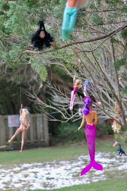
One of the more unusual visions on Ocracoke Island is not on the main drag of restaurants and shops, along the beach or in the water.
It’s on Jackson Circle within a resident’s trees that have up to 100 dolls and doll parts – clothed and bare – hanging from nearly invisible fishing line.
While not wishing to be inundated by passersby, the property owner is unabashedly delighted if her loosely artistic display can turn up the corners of a mouth.
“If I can make people smile, so much the better,” said Susan Dodd, an Ocracoke resident since 1989 and the dolls-in-trees artist for 20 years in two island locations.
Thieves are not welcome, but photographers are.
If she’s not busy with artwork she creates inside her home, she may emerge outside with her own smile, laughter and two spaniels.
On a recent spring day, she pointed to a favorite Barbie-like, purple mermaid. Most of the dolls come from thrift stores where she also buys many of her clothes.
Susan Dodd with her dogs. Photo by Patty Huston-Holm
Dolls and other creations inside her house tend to reflect her social justice sentiments that include America’s 2003 to 2011 Iraq war involvement.
Some figurines appear trapped behind wires and nails. Except for an occasional charity event, these are not for sale.
Dodd is more than a doll lady. She has written seven books, was once married to former U.S. Senator Chris Dodd and is a former lecturer at five universities, including Harvard.
As an undergraduate at Georgetown University, she unsuccessfully challenged Bill Clinton for sophomore class president.
“I don’t identify as any of those things today,” Dodd said. “I came to Ocracoke because it seemed like a good place to write. But I got tired of publishing and started to see writing as too isolating.”
Dodd also doesn’t identify as a doll expert. She doesn’t expound about the earliest documented dolls that go back to the ancient civilizations of Egypt, Greece and Rome.
Nor does she talk about doll manufacturing that has its roots in 15th century Germany.
Dodd suggested that her doll fascination might be connected to the fact that she had few dolls when growing up in the 1950s.
She pointed to her 1999 novel, The Mourners’ Bench, as perhaps the biggest inspiration, followed in 2001 by The Silent Woman.
The “bench” book – loosely referencing a church pew once designated for people grieving or seeking salvation –uses dolls as a metaphor for a theme of broken people.
A detail of Dodd’s yard art. Photo by Patty Huston-Holm
In The Silent Woman, based on Austrian painter Oskar Kokoschka’s love obsession with Alma Mahler, widow of a composer, a life-sized replica of Alma emerges alongside the end of the relationship in 1918.
Now in her 70s, with macular degeneration and two newly replaced hips, Dodd sees herself as simply a dabbler in art and a caregiver.
Looking after others became her untrained but willing and natural role after 9/11 when she moved in with an ex-sister-in-law, who then was a single mother fighting cancer in Kansas City, Mo.
Following the lost battle, the daughter, now age 35, became the child that Dodd never had. Likewise, in the aftermath of Hurricane Dorian in 2019, Dodd assumed the role of caseworker on a disaster relief team for Ocracoke victims of the storm.
As Dodd talked, a mismatch of bracelets, dangling from her right wrist, helps tell her story. The bangles started with ones made by orphan girls she met during a mission trip to Honduras in 2018.
A black one signifies her two-decades-long desire to abolish the death penalty, including for around 100 Missouri, North Carolina and Texas inmates she has met personally.
These men are “not the same person” as when they committed a crime, she said.
Dodd’s experiences and novels divulge human flaws, forgiveness, mental illness and aspects of death and dying – a contrast to the lighthearted laughter of the woman still collecting dolls for her trees while planning an upcoming sacred beach fire burning of “literally hundreds” of “confidential” death row inmate letters.
Dodd believes her writing life is over, but sharing her life is not.
Reflecting on her artistic expression of dolls flying magically through trees, she said their reason might simply be for “my own delight.”
Patty Huston-Holm, an Ohio journalist, spent a month in the spring with the Observer to write a number of stories.
The roiling ocean at Ramp 63 around noon Sept. 23. Photo: C. Leinbach
Update: As of 8 a.m. Sunday, Hatteras Inlet ferries have resumed and all of NC 12 is passable.
Ocracoke Island was drying out Saturday as Tropical Storm Ophelia made landfall south of Ocracoke on Emerald Isle around 6 a.m. and was heading north into mainland North Carolina and northward.
The sun peaked out of scattered overhead clouds and the wind, though still strong on the beach, had been dying down since the morning. Sunday’s forecast is for sunny weather and wind speeds in the low mph teens.
According to the National Weather Service (NWS) bulletins, a storm surge warning is still in effect for Ocracoke inlet.
Ferry service remained suspended on Saturday afternoon.
Ophelia as of 2:30 pm Sept. 23
While the highest winds have passed, flooding is still a substantial threat, the NWS said on Facebook.
The easterly wind flow is expected to peak sometime in the late afternoon on Saturday, and as the storm moves north, the wind will switch to the south and southwest.
As the shift occurs, wind speed will also drop, which could lead to a quick return of sound water that was pushed west.
Should this occur, the potential for soundside flooding impacts will increase, and 2-4 feet of above-ground inundation is possible.
High tide for Ocracoke is at 2:31 p.m.
To sign up to receive alerts if water levels in your area begin to rise due to storm surge, visit www.FIMAN.NC.gov and select the flood gauge(s) located in the waterway you’d like to monitor in real-time.
On the forecast track, the center of Ophelia will move across eastern North Carolina this morning, and then move into southeastern Virginia and the Delmarva Peninsula by the end of today and into Sunday.
Maximum sustained winds have decreased to near 65 mph (105 km/h) with higher gusts. Further weakening is expected through the rest of the weekend, and Ophelia is likely to become a post-tropical cyclone tonight or Sunday morning.
A drive around Ocracoke village Friday evening before dark and Saturday showed puddles of water in locations typically seen in storms.
Ocean conditions will remain unsafe for swimming for the next several days. The public should check surf and swimming conditions before heading to the beach, and the daily beach forecast at www.weather.gov/beach/mhx includes rip current risk levels, and information about other hazards along the shoreline.
Wind gusts from Ophelia were measured as high as 72 mph at Cape Lookout Saturday morning.
More than 80,000 customers had lost power as of 8 a.m., according to PowerOutage.US, with about one half of that number in North Carolina.
There was no overwash at the hotspot on the north end of N.C. 12 around noon on Sept. 23. Photo: C. Leinbach
The Ocracoke pony herd was happily munching its lunch on Sept. 23. Photo: C. Leinbach
Windy conditions off Ramp 70 on Ocracoke Friday evening Sept. 22. Photo: C. Leinbach
Update at 8:47 p.m. Friday: Conditions are expected to continue to deteriorate overnight with the greatest impacts expected Saturday morning.
Tropical-storm-force winds will persist until late Saturday night. The easterly wind flow is expected to peak sometime in the late afternoon on Saturday, and in the evening, the storm is expected to move north with the wind shifting to the south and southwest.
As the shift occurs, wind speed will also drop, which could lead to a quick return of sound water that was pushed west.
Should this occur, the potential for soundside flooding impacts will increase.
A drive around Ocracoke village Friday evening before dark showed puddles of water in locations typically seen in storms.
Update as of 3 p.m. Friday: The National Weather Service has upgraded PTS 16 to Tropical Storm Ophelia. Expected impacts, including storm surge, wind, heavy rain, and tornadoes have not changed. The track (see below) also has not changed.
Storm surge alerts have been issued for the area.
Update As of 7 a.m. Friday: all ferry services to and from Ocracoke are suspended due to the weather.
From our news services
A tropical storm warning and storm surge watch has been issued for all of Hyde County which has issued a state of emergency that will go into effect at 5 p.m. today (Sept. 21), in advance of tropical storm conditions.
A high surf advisory is also in effect, according to a press release.
Hyde County offices and all solid waste convenience sites will be closed on Friday due to predicted storm conditions.
All sound class ferries have been canceled for Friday. Check NCDOT Ferry Division’s press releases for further information on ferry routes.
A low-pressure system developing off the coast will affect our area tomorrow through Saturday.
This system, Potential Tropical Cyclone Sixteen, could become Tropical Storm Ophelia. We can expect tropical storm-force winds (39-73mph), heavy rain, dangerous surf, and storm surge.
Storm prediction’s key points:
Storm surge inundation around 2 to 4 feet above ground is possible.
Winds that should peak at 45 to 55 mph with gusts up to 70 mph are expected to begin on Friday and continue through Saturday afternoon.
Widespread rainfall of 2 to 4 inches, with locally higher amounts, could result in flash flooding issues, especially around urban and poor drainage areas.
A few tornadoes could bring locally enhanced damage, mainly across the Outer and Inner Banks and Down East Carteret County.
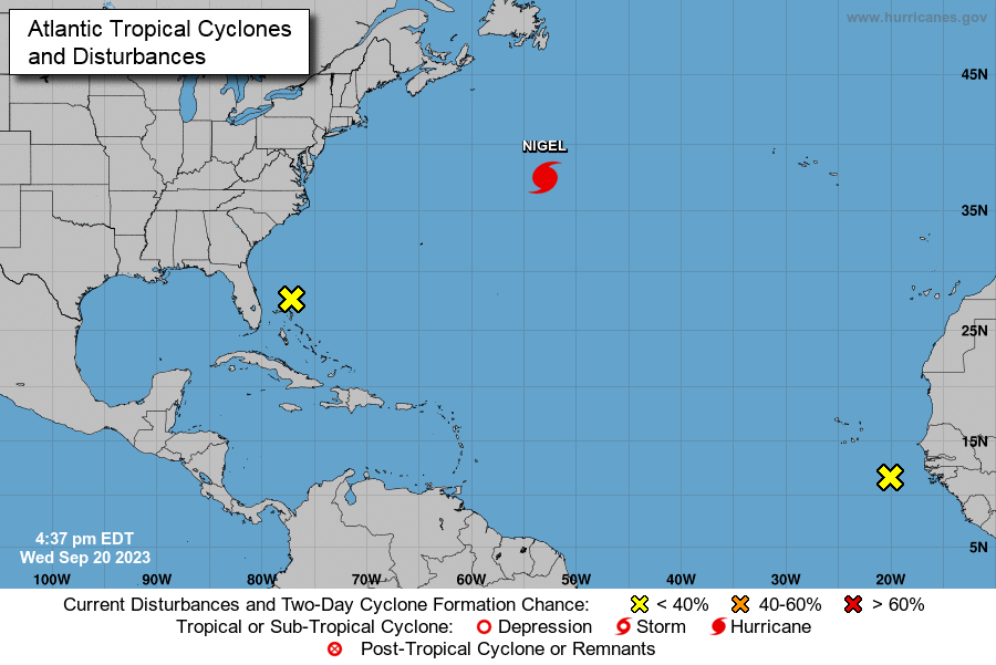
Well offshore, Hurricane Nigel is expected to contribute to life-threatening surf conditions with rip currents and dangerous marine conditions continue through the weekend.
Travel on N.C. Highway 12 may be impacted by ocean overwash at vulnerable locations, especially during high tide.
Citizens and visitors should begin preparations now to protect property that is susceptible to wind and flooding. Residents and visitors should use caution when visiting Hyde County beaches and to stay out of the ocean.
Hyde County Emergency Services will continue to monitor the forecast and issue advisories as appropriate. For the most current and official information please visit the National Hurricane Center website at https://www.nhc.noaa.gov/ and tune in to your local news.
By Sunday morning, the storm will have left the Outer Banks. Forecasts call for partly cloudy with a high of 79F and winds SW at 10 to 15 mph.
Tropical storms have sustained winds of about 35 miles per hour, with higher gusts. Tropical disturbances are named when they have sustained winds of 39 m.p.h.
Adult blue land crab spotted in Emerald Isle, N.C. (Photo: D. O’Leary)
MOREHEAD CITY – The N.C. Division of Marine Fisheries is asking people to be on the lookout for blue land crabs, Cardisoma guanhumi, and to report sightings.
Blue land crabs are a non-native species to the Carolinas that look like an enormous fiddler crab. There has been a spate of recent reports of blue land crabs spotted in North Carolina and South Carolina, and biologists are requesting public assistance to help them learn more about where the non-native species is spreading by reporting any sightings.
Blue land crabs are native to the Atlantic coast from Brazil to South Florida, but occasional sightings of the large crabs have been reported in South Carolina since 2008. The first confirmed blue land crab sighting in North Carolina occurred in the summer of 2023.
Researchers do not yet know the extent of the crab’s distribution throughout the Carolinas nor its impact on the environment and other wildlife. Whether the species arrived through natural expansion of its range or human-mediated sources is also not clear.
Despite their name, the crabs vary widely in color. Adult males tend to have the characteristic blue-gray coloring, but females can also be white or ash-gray, and juveniles can range from orangish to dark brown to purple.
They’re also unusually long-lived and slow growing among crabs, reaching maturity at four years of age and surviving up to 11 years. For more information and images please visit the Blue Land Crab Species Profile Page.
Blue land crabs are difficult to catch. In addition to their speed at retreating into burrows deep below ground, the crabs possess a large claw that they can use to dexterously defend themselves. If you see one of these crabs, biologists encourage you to snap a photo and report the date and the location of your sighting at the link below.
Biologists suspect the crabs may be more visible following heavy rains which can drive them out of their burrows.
For more information, please contact Robert Corbett at Robert.Corbett@deq.nc.gov with the NC Division of Marine Fisheries or Bronwyn at Williams Bronwyn.Williams@naturalsciences.org with the N.C. Museum of Natural Sciences.
Late summer on Ocracoke Island. Photo: P. Vankevich
From our news services
Swells from another distant hurricane–Nigel–will reach eastern North Carolina beaches late this week into the weekend, bringing the possibility of overwash, powerful surf and an elevated rip current risk.
Also, the Outer Banks can expect rainfall beginning Friday as a low pressure develops off the southeast coast of the United States and tracks toward the Carolinas through the weekend, according to the NWS Forecast Office out of Newport/Morehead City.
The threat of strong winds, coastal flooding on both ocean and sound side and dangerous marine conditions, is dependent on the track and strength of the low and is very uncertain as of 2 p.m. on Wednesday. The forecast will be updated as more information is gathered.