

Kayaking in the Pacific Northwest
By Jim Borland
Photos by David Gillispie
Even in summer months, cool weather is the normal fare for the west coast of Vancouver Island, British Columbia.
So as my good friend and kayak companion islander Bill Monticone and I arrived in the last part of July for a week-long ocean kayak expedition to the remote and wild Brooks Peninsula, we were somewhat surprised to find drought and hot weather.
Even so, we enjoyed the cooler temps in comparison to our hot and humid Ocracoke weather.
Our group included Dave and Beth, both entomologists (bug specialists) who were celebrating their 40th wedding anniversary with this challenging trip, as well as Paul, an architect from Vancouver, and Masio, an English professor.
Before kayaking, we motored across the hundred miles of Vancouver Island, bisected by a substantial mountain range, until we reached the western coast of the small First Nation village of Kyoquot.
Then we headed for our West Coast Expeditions base camp at Spring Island.
In an exploratory paddle, the guides evaluated our kayaking strengths and weaknesses. This was my first encounter with the Pacific Ocean, and it was sobering. The enormous power of the swells makes our East Coast look meek and mild.
A family of nine wolves was living just outside the camp, which is almost unprecedented as normally wolves avoid people. For some unknown reason, they had been coexisting for several months on the island.
Later that night, we were awakened by the wolves howling–an eerie, but pleasant sound.
With a fair weather forecast the next morning, we paddled an arduous, 15-plus miles to the un-glaciered and unlogged Brooks Peninsula and our next campsite.
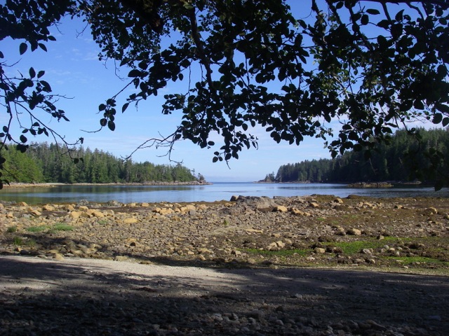
Most of these small islands were littered with 20- to-40 foot logs. The beautiful and huge trees were mostly western cedar, Douglas fir and hemlock, with a smattering of spruce. The Pacific lapped lazily at the shoreline.
Before dinner that night, a black bear emerged from the woods down the beach from us and began meandering our way.
As directed by Sarah, one of our two guides, we began shouting, “Go away, bear!” It finally went back into the woods.
The next day we had an easier day paddling, maybe nine miles, to Brooks Peninsula, a large swath of land owned by a local First Nation.
Virtually untouched by the last ice age, it harbors many ancient species of plants, and, being unlogged, some of the oldest trees on the planet.
We pulled up to a long, stony beach lined with magnificent old growth trees, many so big we couldn’t see the tops. We pitched our tents under those 1,000-year-old giants.
Our next day consisted of a strenuous hike over heavily wooded terrain and huge black, volcanic rocks.
Sorry to leave Brooks Peninsula, we headed out on day three as soon as the tide allowed.
The tides in that area of the country are impressive, sometimes 50 to 75 feet laterally.
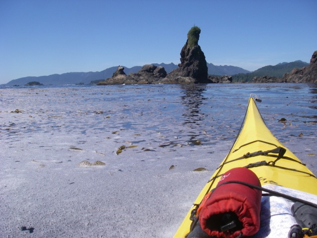
That day, we headed for the mainland about nine miles away. As we skirted the coast, we saw numerous bald eagles, some sea otters and seals.
Soon after a long haul and some choppy swells, we came to a calm sandy beach. We had been paddling hard and were hot and tired.
So into the 50-degree water we went.
Day four we were off to The Bunsbys, a series of islands about half way between Spring Island and The Brooks Peninsula.
Our first stop was at a First Nation fish weir, which is a fence-like sluice created in the water to catch fish.
The First Nation people of the area drive fish into the weir by beating the waters with their paddles. They herd the fish in and by closing the opening, they manage to trap large schools of fish.
Then the women and other members of the band scoop the fish into cedar bags and other containers to be cleaned and dried on the beach.
It was almost magical to be there and see their historical way of harvesting so many fish.
Before we paddled to our last campsite–a small island in the Bunsbys–we visited “green head,” a local rock outcropping with a huge head of trees on its top. It reminded us of a totem.
The last day on the water, we had to find the right beach–not too steep, and with decent, but not dangerous, surf. After some exploring we came upon a good candidate.
Sarah gave us specific instructions about landing by riding right behind the crest of the wave. If done correctly, you floated nicely onto the beach.
After a short break, we headed back out to sea, but in a different process: catching the wave at the right time so it would carry us out and over the surf.
What a rush. Scary, but exciting.
Our next challenge was a sea cave–an opening created by eons of heavy surf.
The cave was cool and dark, but had enough light to allow us to paddle. Finally we turned into an opening, saw light and made our way out. Wow! It felt great.
Afterwards, we headed home through some good chop until we saw our final landing at Spring Island. We headed in for the last time.

The next morning, the adventure continued as we awakened to the sound of the wolves again.
The whole family was on the tidal flats right outside our tents.
We ran outside with cameras and binoculars and saw two adult wolves with at least six pups foraging and frolicking on the flats.
What a spectacular end after almost 55 miles on the water.


