
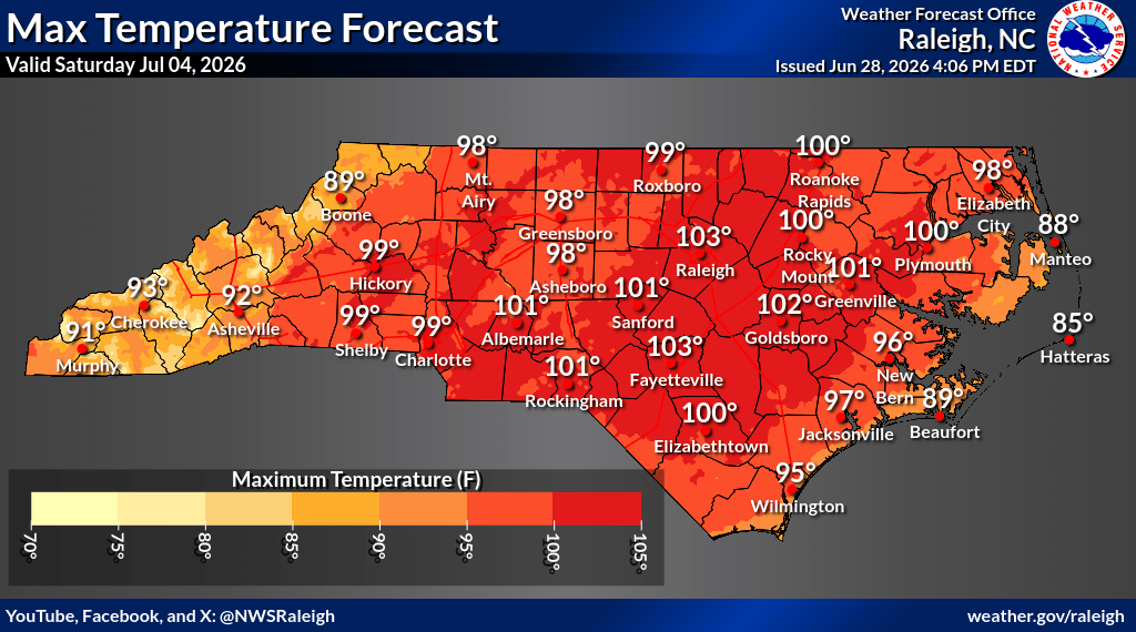
A prolonged and potentially dangerous heat wave is expected to grip eastern North Carolina and the Outer Banks beginning midweek and intensifying into the July Fourth holiday weekend, with updated forecast data showing much of inland North Carolina reaching or exceeding 100 degrees for several consecutive days.
Meteorologists with the National Weather Service say confidence remains high that a powerful upper-level ridge will settle over the eastern United States, producing one of the region’s most significant heat events in years.
Forecasters warn the worst conditions are expected from Thursday through Saturday, when inland temperatures could climb above 100 degrees and heat index values — the “feels like” temperature when humidity is factored in — may reach 105 to 110 degrees, with isolated spots exceeding 110.
Despite somewhat lower air temperatures at the beaches, forecasters warn the coast may experience heat index values comparable to inland areas because of elevated humidity and limited overnight cooling.
The weather pattern driving the event is known as an omega block, a large-scale atmospheric setup where a strong ridge becomes trapped between surrounding troughs, allowing heat to build and persist for days.
The Newport office said heat risk probabilities for eastern North Carolina are especially concerning this far in advance.
The chance of reaching major heat risk levels is currently estimated at 60% to 80% Thursday and rises to 80% to 90% Friday and Saturday.
Forecasters say nighttime lows remaining in the 70s will add to the danger by providing little overnight relief.
Health officials warn prolonged heat exposure can quickly become dangerous, especially for older adults, young children, outdoor workers and people with chronic medical conditions.
Rain chances remain very low through at least Friday, meaning little natural cooling is expected.
Forecasters say heat advisories, extreme heat watches or warnings may be issued later this week as confidence grows in the exact severity and duration of the event.


